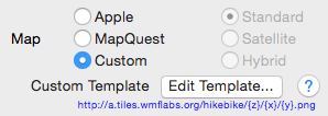
The Custom Template feature in Land Measure Pro allows you to add an alternative base map.
After pressing "Edit Template…” you should provide a string that specifies a URL to a TMS server and the naming schema of the map tiles.
This is a string representing a template for the final URL that will be used to retrieve map tiles: this template will contain some placeholders that will be replaced by effective values to get the final URL. The URL needs to contain 3 parameters: x and y for the tile indexes in the map plane, z for the zoom level. The corresponding placeholders for these parameters are: {x} {y} {z}. So as an example, the OpenStreetMap template URL will be http://c.tile.openstreetmap.org/{z}/{x}/{y}.png
There is a good explanation of map tiles and URL schemes here.
Below are some example templates that can be cut&paste directly to the Edit Template dialog. NOTE: I take no responsibility for the reliability of these map servers. Please check their license agreements before using.
Open
Map: http://otile1.mqcdn.com/tiles/1.0.0/map/{z}/{x}/{y}.jpg
Satellite: http://otile1.mqcdn.com/tiles/1.0.0/sat/{z}/{x}/{y}.jpg
Sea: http://tiles.openseamap.org/seamark/{z}/{x}/{y}.png
Watercolors: http://c.tile.stamen.com/watercolor/{z}/{x}/{y}.jpg
Cycle: http://a.tile.opencyclemap.org/cycle/{z}/{x}/{y}.png
Hillshading: http://c.tiles.wmflabs.org/hillshading/{z}/{x}/{y}.png
Thunderforest Topo: http://a.tile.thunderforest.com/landscape/{z}/{x}/{y}.png
Thunderforst Outdoors: http://a.tile.thunderforest.com/outdoors/{z}/{x}/{y}.png
ArcGIS
World Topo: http://services.arcgisonline.com/ArcGIS/rest/services/World_Topo_Map/MapServer/tile//{z}/{y}/{x}.png
NatGeo: http://services.arcgisonline.com/ArcGIS/rest/services/NatGeo_World_Map/MapServer/tile//{z}/{y}/{x}.png