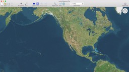
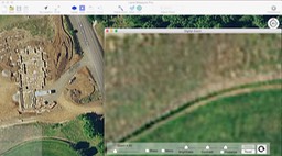
Looking for an affordable map based measuring solution that is easy to use, is packed with professional functionality and works on your Mac desktop or laptop? Look no further.
Measure area, lengths and angles on a map.
Multiple layers allow multiple measurements to be combined into one document.
Customizable colors and labels for each layer. Store measurements locally, output professional images to printer.
Trace the outline of any feature visible on the map, creating a series of connected points the area and perimeter are continuously updated.
Extremely complex shapes can be handled with virtually no limit.
The default map is Apple’s own map system. If you want to know what is visible on the map you can look at the default Apple Map application. The level of detail is exactly the same as in Land Measure. In addition you can use a different base map such as OpenStreetMap.
If you want to overlay drawings, sketches or scanned data then you can use the ability to add an overlay image. If you want to overlay CAD or PDF data, simply output them to a high resolution image and follow the instructions to add an overlay image.
Can be switched between Metric and Imperial units (hectares, sq.km. sq.m, acres, sq.miles, sq.yrds, sq.ft) at any time, and can be switched from measuring areas to simple lengths.
You can zoom to your current location, search for an address, or manually pan/zoom to any place in the world.
Similar functionality to the iOS version but on the big screen of a desktop computer or laptop. Will open files created from the following iOS apps: Land Measure Pro, MyMeasure, Real Estate Measure


